August 9, 2009
We began hiking early, around 5:30 a.m. when most hikers set out to avoid getting caught in an afternoon storm. We made it just past the infamous "Chicken Out Ridge", a steep, knife-like rocky ridge, when we (and apparently most other hikers near the top) turned around and quickly descended to avoid the fast approaching thunder, lightening, hail and rain storm. The level three hike is steep and rocky requiring rock climbing using hands and feet or scrambling. Be prepared to hike on loose shale and rock and for adverse and fluctuating weather conditions. Expect to take around 8-10 hours to complete. The views throughout the hike are breathtaking!
Mt. Borah Overview
Elevation: 12,662 feet
Mileage: 6.8 miles round trip
Vertical Gain: 5,500 feet
Trail head Elevation: 7,460 feet
Average Hiking Time: Total around 8-10 hours
Season: May through November. Best hiking mid July to mid August
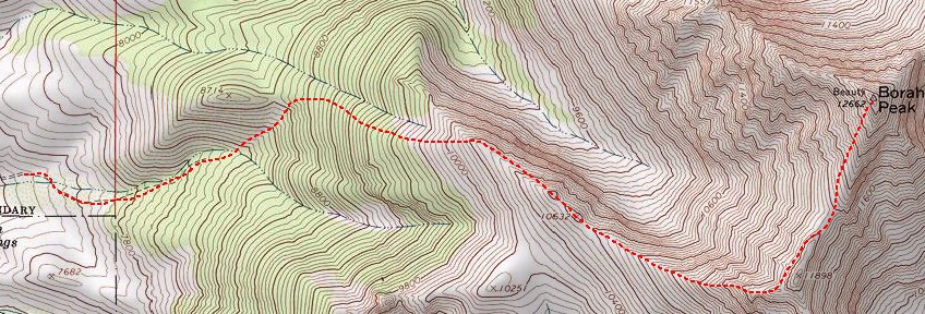
Route
From the trail head, follow the trail into the forest. The hard-packed steep trail switch backs for about 1.1 miles before leaving the treeline. Continue north on the trail up an exposed steep and loose shale and rock covered face until reaching the bottom of Chicken Out Ridge that starts around 11,300 feet. Chicken Out Ridge is a knife-like ridge with steep drop offs on either side covering a 0.2 mile stretch of class three climbing on a non-specific trail. Other hikers suggested hiking on top rather than on the side of the ridge. However, there is no distinct trail and requires finding your way. Continue hiking to the saddle and across a snow-covered bridge (note: during the height of the summer, there may not be much snow). Cross the saddle and follow the loose rock and steep trail up the last 800 - 1000 feet to the summit.
Getting There
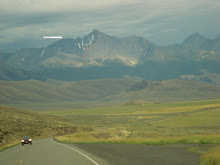
Mt. Borah can be reached from U.S. Highway 93 by driving north of Mackay 21 miles or south of Challis 33 miles. Turn east on Birch Springs Road at the sign for the Mount Borah trail head. Drive about 3.5 miles to the trail head. A few camp spots are available near the trail head including an outhouse and parking.
What to Expect
Mount Borah trail is not a complex and technical climb but can be very fatiguing due to the steep, level three slopes. Most people don’t use ropes and some carry an ice-ax for self-arresting if necessary on the small and steep snow field near the top. Be prepared for adverse and mixed weather conditions. During the summer, the weather at the base can be warm, even hot changing to cooler and windy conditions near the top. There are several steep and vertical drop offs near the trail and the mountain may be snow covered. As well, afternoon storms are common during the summer so check conditions before setting out. The hike can also be arduous following a steep, around 30% grade. Plan to complete the hike (round trip) in about 10 hours. There are no facilities so take essentials including plenty of liquids and adequate food. Photo buffs may enjoy bringing a (lightweight) camera to capture magnificent scenic shots. Best climbing conditions are mid July to mid August.
Trailhead Facilities
Campsites: Five, each with a picnic table and fire pit (sites can fill up quickly by a weekend evening).
Toilet: One outhouse
Fees: none
Facilities: no water
What to Bring
- Sturdy and comfortable hiking shoes
- Clothes for mixed weather conditions including a hat and rain and/or wind jacket and hiking pants to avoid getting scratches and cuts from the rocks
- Gloves for climbing on the rocks
- Lots of water and adequate food
- Sun screen
- Bug repellent (can be many mosquitoes in the forested area)
- Lightweight camera
- Hiking stick (although some found them cumbersome on the rocky areas)
- Ice Axe (for snow areas although some claim they are not necessary if there are already foot holds etched in hard-packed snow)
- Backpack for hiking essentials (and to store extra clothes if needed)
Map quest: http://www.mapquest.com/
Map
Click here for a top map of Mt. Borah: http://idahosummits.com/borah_feature/images/topo2.jpg
Links
List of the highest points in the United States: http://geology.com/state-high-points.shtml
List of the highest mountains by U.S. state: http://www.e-referencedesk.com/resources/almanac/highest-peaks.html
Contact Information
Lost River Ranger District
716 W Custer
P.O. Box 507
Mackay, Idaho 83251
Phone: (208) 588-3400
Fax: (208) 588-2924
- Lisa Kleiman


